I got in pretty late last night. I believe Lima is in the eastern time zone. So even though it was 12:30 am when I got to bed it was only 9:30 by my clock. The airplane seats were very comfortable so the trip here wasn't very tiring.
Lima, at midnight on Easter, wasn't very inviting. I think the airport is in a poorer part of town. Lots of people ambling about though. Piles of trash everywhere. Very much a third world feel. I was inside a company vehicle with a driver so I felt pretty safe. Although "driving" here is a different experience. The horn becomes as essential as the gas pedal, for example. I got to the hotel, which is small, but clean and very nice. It's across the street from the US Embassy. I have about 3 or 4 hours now to do something. Not sure what. Easter in an 80% catholic country means just about everything is closed. I need to hang around the room for a bit to determine exactly how I will get to the airport. I have no cell phone access. Just email and internet, when there is WIFI.
This afternoon, I fly to Trujillo, a smaller city about an hour to the north. Then, tomorrow, by bus to the mine at 13000-14000 feet.
The weather here is really good. Warm and a little humid. I like it.
When we are not at work, what do we do? That's what this blog is about. The outdoors, healthy activities, technology that makes life easier, fun with friends and family - here's how to do it right!
Sunday, April 24, 2011

Saturday, April 23, 2011
Day 1 - I'm a traveling man
So, as I sit here at McCarran Airport in Las Vegas I am marveling at how flight has changed since the olden days when you sat in the open cockpit. LOL. No, but it has really changed a lot since I started flying in the 60's. For example, from my Blackberry, I can call up a webpage for the airline and instantly know if the plane is on time or late. I can make a reservation, buy a ticket, change seats. At some airports, I can even check in and get an electronic boarding pass - all on the phone. My laptop is plugged in, I'm enjoying a Starbucks white chocolate mocha and the free WIFI here lets me send and receive email as well as check up on my social networking pages. Indeed, pretty amazing.
Security is a pain these days. They put you through the whole body scanner (the one where your nekeddness is displayed for the world to see) and you practically need a locker room to get dressed again on the other side. There seriously has to be a better way. If I were in charge, I'd find a way to identify the terrorists in advance and focus my efforts on them. We are wasting so much time on people who are simply ordinary while the real danger finds a way to bypass the system. Oh well.
The plane boards in half an hour. Business class (first class when BC is not available) means comfortable seats, free drinks, movies, and good food. I've got a window seat and I'll definitely be taking pictures if there are pictures to take (depends on lighting and clouds). I'm bound for Houston where I change planes and then head to Lima, Peru - where I arrive (if on time) at 10:25 tonight. Then, a driver is supposed to meet me at the airport and take me to the Polo Hotel - a pretty decent place in the University section of Lima. Based on a Google Earth investigation, there appear to be some small mountains within walking distance of the hotel. As it is Easter Sunday tomorrow, and Peru is 80+% catholic, I am expecting everything to be closed. So a nice morning hike may definitely be in order. We will see. Sunday late afternoon I head on another plane to Trujillo where Monday morning we head by bus along a narrow winding highway to the mine.
I found a map from a site investigation of the mine done several years ago. It plots out the location of archaeological sites potentially impacted by the mining activities. Some of them are "pre-Spanish) - which I have to assume means Inca. This is no Machu Pichu, may just be stone chipping sites, but if I get a chance I'm going to try to check them out.
Later,
R
Friday, April 22, 2011
Going to Peru - Part 1
Hi All. Well, I am leaving for Peru tomorrow. I will be there a week. It is entirely a work trip. I am visiting one of the Barrick mines in northern Peru called Lagunas Norte to help implement a new project management tool. If I am lucky, I will have some time a week from tonight (a friday) afternoon and evening to see something in the Lima Area. Otherwise, I am going to be at a "Camp" at 12,000 feet or so and working. The camp is not a tent. Its habitized containers. There is a mess hall and perhaps a recreation area. I am taking my harmonica so maybe I'll get a chance to share some American folk music.
Of note, they've given me a pretty thorough physical and inoculated me against all sorts of dread diseases including Typhoid, yellow fever, and malaria. A bunch of routine things as well.
On the positive side, I get to fly business class since it is an international trip. Woo hoo!
Here is a video about the mine. It's in Spanish but even if you don't speak the language you can get an idea of just how spectacular a place the Andes are.
http://www.youtube.com/watch?v=gkgSiCT1Tdw
I'll try to provide regular updates and pictures.
Monday, March 7, 2011
Winter must be over
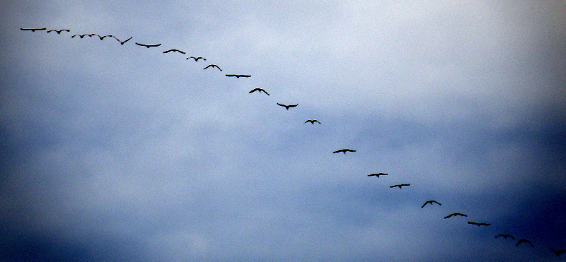
Sandhill Cranes flying north. Apparently these particular cranes wintered in the Salton Sea (California) and are headed back to Northern Nevada/Idaho and across Canada and Alaska to Siberia.




Saturday, February 19, 2011
Snowshoe Trails in Lamoille Canyon

Route 1 – Nobody Goes Here
A good route for exercise. On snowshoes, it can only be done with the deepest of snowpacks. But when the sagebrush is covered, it is a nice heart-pumping climb with some beautiful views. Watch it when there is fresh powder. The sagebrush gets covered in snow but is not well compacted, making it easy to sink below your waist!
Drive to the Powerhouse picnic area on the right hand side of the road. Park your car in any open spot on the Lamoille canyon road. Walk in past the second cattle guard. Then head up the ridge on your right. As long as you stay to the left of the fence line you are on public land. Make your way up the steep hill and then follow the ridgeline as high as you want to go.
Route 2 – Talbot Canyon Trail
This is a new trail. Park in the pull out off the Lamoille canyon road just above the Powerhouse picnic area. This trail was designed for hikers, equestrians, and even mountain bikes. That means the trail is pretty wide and it’s got a lot of switchbacks. Perfect for snowshoeing. It’s 11 miles one-way over to Talbot Canyon. So hike in as far as you want and then turn around. Great views of the Spring Creek Valley and Elko peak area. You’ll want to go right after a snowstorm or during the snow season as this trail becomes a hiking trail as the snow line rises up the mountainside.
Route 3 – Lyon’s Camp
I usually park out on the Lamoille Canyon road and then tramp down the dirt road to the campground. This private campground, operated by the Lyon’s Club, is closed from Oct thru May. But it’s perfectly legal to walk on the road and on the trail through the camp. I usually stay to the right of the stream. After awhile, you’ll go through a marsh/meadow area (no issue if there is snow) and soon after that it get’s steep and hard to navigate through the brush – which is where I turn around. I’m told you can go up even higher but I don’t know the exact route. Certainly avalanches are a concern under some conditions if you go up much above the marsh.
Route 4 – Thomas Canyon
I love this route. Potentially, you can park on the Lamoille Canyon road above Lyons Camp where all the snowmobilers park. But you have to deal with snowmobilers for about 1.5 miles before you can leave the road and head up the canyon.
So really this is more of a later-season route once the road is clear to higher elevations. During these times, park by the Thomas Canyon campground. Tramp through the campground and locate the trail heading up the canyon. Convenient bridges take you across the raging river. Then just head up. Pick the most open route you can, avoiding the cliffs by the stream. The initial half-mile is the steepest, and it is pretty steep. Then the canyon levels out for a bit and then gets steeper as you approach the basin in front of Mt. Fitzgerald. Go up as high as you want, heading towards Mt. Fitzgerald and keeping to the left of the stream. Snowmobilers are not allowed in this canyon. So you’ll see coyote’s and maybe even beavers in their wooden lodges.
Some day, I am going to investigate crossing what looks like a pass in the mountains and head down to Island Lake. But this is a ski mountaineering route, not a snowshoe route. And there could be some danger – so if you try this, be prepared.
Route 5 – Lamoille Lake
Again, this is best as a late season trip when you can make the drive all the way to the turnaround. You will have to deal with snowmobilers so stay away from open areas on hills where you might not be visible to a snowmobiler traveling quickly or coming around a blind corner.
The route pretty much follows the horse trail up to the lake.
2010 - The year of Recovery
Hi. Well, some of you know that in 2009 I lost my job, thank you Recession, and was unemployed for about 4 months. I found contract work in Idaho that led to an actual job at a gold mine in Northern Nevada in early 2010. So most of 2010 was attempting to rebalance my life! Recovery, if you will. By the way, that recovery is still underway but things are coming together. Anyway, if you have a few minutes, I summarized my experiences of 2010 in the following video:
2010 - the year of Recovery
2010 - the year of Recovery
Saturday, February 12, 2011
A gift of conversion
Hi Everyone: I've been traveling to Canada a lot lately. Up there they use universally (to Americans) strange units of measure. For example, they use the Celsius scale for temperature measurement. They use something called Kilometers to measure distance. It's all very different. But then I realized that the Fahrenheit scale and something called "miles" would seem strange to most other people around the world. So to help out the world, I created the following graphic:


It can be uploaded to your Blackberry (or other similar device) and delegated to the background so it is always visible. It ranges from 1 to 10 miles. So, for example, 6 miles = 9.61 km. Plus, 60 miles = 96.1 km so the scale can be expanded quite a lot. For the temperature scale, I added color coding (red for hot temperatures and purple for cold). I picked the range of temperatures for where I live - yes, in Elko it can get to -20 and it has made it over 100 on occasion.
So, you are welcome!
Subscribe to:
Posts (Atom)